On the afternoon of October 10, 2020, after a long journey of nearly 500 kilometers, the scientific expedition team arrived at Bosten Lake, the largest inland freshwater lake in China. This is the first stop of the China Biodiversity Conservation and Green Development Foundation (CBCGDF) Lop Nur scientific investigation expedition. The reason for choosing Bosten Lake is closely related to water. Because today's Bosten Lake is undoubtedly the largest and most important freshwater lake in the Tarim Basin.
Bosten Lake is a freshwater lake on the northeastern rim of the Tarim Basin, about 20 km (12 mi) east of Yanqi and 57 km (35 mi) northeast of Korla, Xinjiang, China in the Bayin'gholin Mongol Autonomous Prefecture. Covering an area of about 1,000 km2 (390 sq mi) (together with adjacent small lakes), it is the largest lake in Xinjiang and one of the largest inland freshwater lakes in China. Bosten Lake receives water inflow from a catchment area of 56,000 km2 (22,000 sq mi).
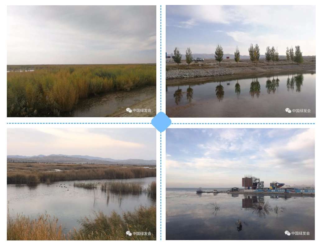
Standing on the shore, one can't see the other side of the lake. The lake is clear and vast, and in the wide wetland of the small lake area, there are forests of reeds, numerous water birds, and rich biodiversity. Bosten Lake is the tailboard of Kaidu River and the source of Kongque (Peacock) River, and Kongque River is one of the important tributaries of Lop Nur downstream. Did you know that in history, the area of Lop Nur, which undertakes important tributaries such as the Kongque River, Tarim River and Cherchen River, has changed many times? The total area of the lake once reached several thousand to ten thousand square kilometers. Also as a freshwater lake, Lop Nur's grandeur in the past is evident from this.
The car hadn't stopped, the members of the expedition team reached the shore and "disappeared" in the wetland on the shore of the Bosten Lake. The reeds there are lush and towering. The soil team and the microbiological investigation team started sampling in the wetlands near the lake shore. They dug up the layers, and with the naked eye one can see that the soil in the wetland is dark, fertile and soft.
On the beach slightly far away from the wetland of the small lake, tamarix chinensis, which is about one person high, is still blooming, and the purple-red spike-like tidbits are very enchanting. The members of the plant investigation team walked into the lake beach and instantly “submerged” in the dense reeds and shrubs. In addition to taking water samples, the fish and plankton survey team also conducted surveys of aquatic organisms in the shallow water near the shore of the small lake.
The waters are rich in biodiversity. Judging from randomly caught freshwater snails, transparent shrimps, and some bottom-dwelling fishes, Bosten Lake today still bears the reputation of the benefits of "fish and salt pampas".
National Highway 314 is like a dividing line, with a large open lake on one side and a small lake with dense reeds on the other. At the southwest headland of Bosten Lake, the terrestrial vertebrate survey team conducted surveys mainly along the highway transect. On a sample line, the scientific expedition team can observe and record as many as 10 kinds of birds. In the reeds, the swarms of wild ducks do not avoid humans very much, and only when the human’s approach, they swim in groups slowly to the distance.
“Today, Bosten Lake, with rippling waters and beautiful aquatic plants, is basically a living sample, because it is not only ecologically closely related to Lop Nur but has also been associated with each other for more than 1,000 years.” Why is Lop Nur, which is located further downstream and the geological depression in the lower part, dried up completely and gradually decertified in the 1970s, but Bosten Lake basically retained its old style? The scientific expedition team believes that studying Bosten Lake from the perspectives of water quality, soil microorganisms, and biological species is precisely to find a key point in the ecological changes of Lop Nur.
According to the plan, the next scientific expedition team will conduct on-site investigations, and it will be another inland river that is more closely related to Lop Nur - the Tarim River and its tributaries.


(Photo credit: CBCGDF)
Original Chinese article:
http://www.cbcgdf.org/NewsShow/4854/14051.html
By / Yao Jiahui (Intern) Modified / Maggie
https://www.paypal.me/CBCGDFChina
http://www.cbcgdf.org/English/ConfirmDonaTion/0.html


(Please indicate "I read CBCGDF" in the payment notes, thank you!)